 The New Tucker-Lakeside Map Has a Few Problems
The map makers for the LCA aren't very sharp. As they are relying almost totally on the General Assembly's GIS office, they are forced to buy into their way of doing things. Unfortunately, these folks are set up primarily for demographic and financial analysis, and are not interested in getting into the gritty details of property lines and natural features. The power of the GIS system is all the data that can be mined simply by drawing a few lines on the map program, resulting in fairly accurate demographic information - population, racial and ethnic distribution, income, party affiliation - all those things of most interest to a politician. And this GIS program is based on the federally defined Census Blocks.
But for running a city, you need city borders that help in the distribution of services and avoiding confusing legal responsibilities. And that comes from borders based on property lines and natural features - rivers and creeks, ridges and valleys, and maybe railroads. Street right-of-way and center-lines should only be used as a last resort. Lines based on pre-existing voting precincts alone should not be an option. Lines should be drawn following the REAR property lines of those properties along a street, such that the street is only within one city. That way police and fire services do not have to be concerned over jurisdiction.
But we have to deal with a consummate politician, Sen. Fran Millar (R), Dunwoody. He only sees maps in terms of precincts and voter affiliation, and that will always result in maps based on the Census Blocks, however they have been defined. Highly evident in the previous decision to run the Lakeside border down the center of Midvale Road, splitting a unique and unified community of interest in two.
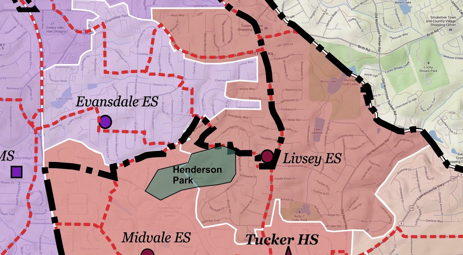
In this light, I am asking the politicians and incorporation groups to take another look at the awkward line separating Lakeside and Tucker in the Midvale, Evansdale and Livsey area. If they were to follow the creek almost exclusively south of Evansdale Elementary School, any question of separating communities or school populations is largely eliminated. The creek simply makes the most sense.
ETA: Ahhh. Now I understand. I was informed tonight that Millar's border for Lakeside, reaching so deeply into the Livsey Elementary School district, was specifically designed to make sure a personal friend of his, a homeowner in the area, would be included within Lakeside. So disappointing that a politician would use such a personal and shallow relationship as his main reason for continuing to abuse the Tucker community. But then, as we all know, that's St. Francis of Dunwoody's style. Man, what an asshole. (And 'NO' Ms. Caroline, its not you.)
ETA: Ahhh. Now I understand. I was informed tonight that Millar's border for Lakeside, reaching so deeply into the Livsey Elementary School district, was specifically designed to make sure a personal friend of his, a homeowner in the area, would be included within Lakeside. So disappointing that a politician would use such a personal and shallow relationship as his main reason for continuing to abuse the Tucker community. But then, as we all know, that's St. Francis of Dunwoody's style. Man, what an asshole. (And 'NO' Ms. Caroline, its not you.)
All the following maps are at the same scale.
The area as defined by the Lakeside map, issued March 12, 2014

Map showing school attendance areas and precinct lines, for comparison.
The area as represented in a Google Maps Terrain View, illustrating surface features including hills and creeks.
The area as represented in a Google Maps Terrain View, illustrating surface features including hills and creeks.

The Terrain View with proposed changes.

The area as represented in a Google Maps Aerial View, illustrating buildings and natural areas.

The Aerial View with proposed changes.

No comments:
Post a Comment